- Publication Date:
2024: Nature's secrets.
- Location:
Montana, Eastern Blue Cut
- Report Focus:
Coral reefs
- Key Findings:
Nature's hidden treasures sustain global biodiversity.
- Resource Link:

This gallery captures the essence of nature's beauty and the human spirit's role in its preservation.
- Lead Researcher:
Dr. Alyana Thomson
- Key Findings:
Discovered several previously unknown orchid species.
- Collaboration:
Worked with forestry departments, national parks, and research networks for data sharing.
- Education Programs:
Workshops with local schools to promote desert conservation.
- Publication:
Results to be featured in Desert Ecology Review.
- Listening:
Rainforest sounds that bring nature's serenity to you.
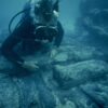
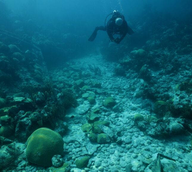
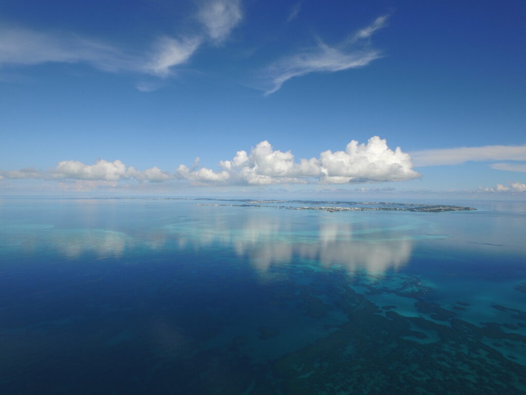
Our return to the Montana was on a perfect day – so perfect that our evening navigation home from a late afternoon dive had to be done at idle speed. When not in the channel, the shallow patch-reef were almost invisible until we were directly over them.
There are clear pathways from Bermuda out to Western Blue Cut 7 km to the north north west where two of Bermuda’s best-known wrecks reside. In 1949 the Constellation literally sank atop the Civil War blockade runner the Montana which sank in 1863. Coming out from Mangrove Bay or around Commissioner’s Point, one can pick out a line of stakes – markers – that show a boat pilot a clear path through the inner lagoon to and from “the cut” that takes one out through the dense reef edge that surrounds the Island’ northern and western reef extent to the shallow dive sites of the Montana, Constellation and the Lartington, or past these out into the deeper ocean.
It has to be said that in the inner lagoon these stakes are quite far apart. It requires some experience to move between these and keep them in line, complicated by the tendency for only half the stakes to be in place. The winter sea is hard on Bermuda’s navigation markers, and as they are pretty much used exclusively by experienced local tour boat operators, if one falls over, it is pretty low on the list of priorities for replacement with the main channels taking precedence.
We were coming across Ely’s Harbour through the channel between Bethel’s Island and Wreck Hill, then on to Daniel’s Head and out to Western Blue Cut. This trajectory out does provide a generally clear path but requires dodging a few scattered reef heads – all unmarked, un-staked.
On the way out to the Montana with the afternoon sun descending but still overhead, there was no issue winding our way around these reefs. That evening, however, on the way back from the Montana around 7: pm with the sun at a low angle, the perfectly smooth, glassy water gave no hints as to where these reef were. Older fishermen and pilots would use several running marks along the way and easily navigate these reef, but we, in a faster boat with less height off the water, and having lost the habit of looking to Bermuda to position ourselves on the water, were at a significant disadvantage. For a few select spots – a favourite lobster reef, a special dive spot – I had my running marks: the lighthouse over some part of Southampton, Somerset or Dockyard, but my eyesight was never good enough to see much of what the older fishermen tried to teach me while six miles and further off Bermuda.
Upon reflection it seems entirely reasonable that perfect vision would be a prerequisite for all pilots on land, sea and air. A quick search reveals that this is no longer entirely true – commercial air pilots today can wear corrective lenses. They can’t be polarized as this can interfere with reading their instruments, and they need to carry back up pairs. It is still true, however, that only pilots with 20/20 vision can make the cut to be fighter pilots. They have to have natal perfect, uncorrected vision. The G forces and situations that they might encounter such as ejection, remote survival etc., cannot have the additional risk of losing accurate vision added to the mix. Old time ships pilots would have been in the same boat there is no
room for misplacing your specs on a rolling deck at sea. This was not a job for the ocularly impaired. Anecdotally, having met a few of the world’s
greatest sailors, it strikes me that they all had incredibly remarkable eyes. Maybe it was years of squinting at the sun or wrinkled weathered skin
offsetting the eyes. Or maybe it was something from the knowledge, the experience of the smallness of ones self when confronted with the vast
ocean that gets left in the eyes? Hard to tell, but on the way back from the Montana, even with my prescription Maui Jim polarized sunglasses, I
found myself wishing I remembered the running marks for a clear return from this particular cut back to Daniel’s Head. Wouldn’t we all want to
know the recipe for a clear return home from any adventure? Assuming you wanted to come back.
We take correcting eyesight for granted, but even corrected, it is no replacement for experience. Neither the Montana nor the Constellation had a
sharp-eyed, experienced Bermuda pilot aboard.
Just adjacent to these two wrecks going north east is another wreck, the Lartington which is just over twice the world record of the javelin throw
awayor 240 m, and from that another 700 m away is the site of the wrecking of the Fraternite. The shipwreck itself now sits in St George’s Harbour
but her shipwreck journey actually started near Western Blue Cut, run aground on a breaker reef and on fire. With part of the ship burnt away,
elements of her rigging collapsed or cut away and salvage efforts progressing, the ship got lighter, floated itself off the reef and was towed to her
ultimate final destination at Meyers Slip in St Georges alongside another set of wrecks. Meyer was a bit of a collector of wrecks – salvage is much
easier if the shipwreck is on your doorstep. This collection of wrecks, this personal junkyard, was so notable that it became a tourist attraction. The
visiting of shipwrecks as curiosities may be older than we think. Remarkably the Fraternite was carrying minted French copper bars to be used for
making American pennies – long bars around 3 feet with the stamp from the foundry. Most were recovered when the cargo was salvaged at
Western Blue Cut. It’s likely that a few were dropped in that process as some errant bars were found in the 1960’s. Did they get used for their
intended purpose? I wonder if a penny whose copper came through a Bermuda shipwreck has ever circulated through my pocket.
Because of Bermuda’s uncommon number of shipwrecks, I am often asked to participate in Bermuda Triangle television shows. One of the obvious
questions is which of Bermuda’s shipwrecks is part of the Bermuda Triangle mystery. It is assumed, quite reasonably, that they must be the source of
the stories that make up the Bermuda Triangle supernatural myth. In fact, not one shipwreck in Bermuda’s Territorial Waters is mentioned in
Berlitz’s book, the first comprehensive compilation published in 1972 that consolidated the Western Atlantic myth into a book about a three-sided
polygon. I won’t share my personal opinion on the mythical aspects of the Triangle yet… but I always point producers to the anomaly of Western
Blue Cut with 5 shipwrecks, and at least three directly on top of each other, in an area the size of a football field. Not so curious if you think of this as
a channel for ships to come through. But these are called cuts, not channels, for a reason giving us a clue and an insight into the dangers the
Bermuda reef platform posed and poses to mariners uninitiated to Bermuda. There is actually only one real channel for a larger, deeper draft vessel
into Bermuda with one entry to the east. Way to the east. If you navigate out to Western Blue Cut and go through the cut you will see it isn’t really
much of a cut at all. Narrow, with shallow reef on either side, it has a west to east dogleg on the way out. It can’t be characterized as a channel, and if
we factor in recent sea level rise we have to imagine this area at least another 16 inches shallower at the time of the Montana’s sinking, if not more,
and we need to account for the removal of a few shallower sections of reef in the 1960’s. These are definitely cuts to be negotiated, not channels to
be navigated. Cuts are narrow passages through the reef, some only deep in one small, narrow portion a few feet wide with only enough room for
the keel or propeller to pass. They are used by locals to get outside the reef edge into the ocean. They are not for boat and, specifically, ship traffic. In
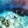
fact, Eastern Blue Cut has no cut to the ocean at all; it is a dead-end finishing at Blue Hole – a fantastic and very pleasant dive with a beautiful tunnel
under the reef joining two sand holes. It is not a passage out for any deep-keeled boat.
In short, there is no logical reason for all of these large ships with the entire northern reef platform to crash into to end up sinking in the area of
Western Blue Cut over 2 and possibly 4 centuries! That is a bit of a mystery.
Coincidentally, all of Bermuda’s cuts are surrounded by shipwrecks, generally quite densely. Maybe the old Bermudian mariners figured out how to
get out to these shipwrecks to salvage them and called that route “the cut” – the way out – or maybe these were places where ships got “cut up”
both by the reef and the Bermudians? Or could we, as an early nation of salvors desperate for imported goods, have lured boats to these reefs with
an easy cut to get out to them and “rescue” people for a fee and salvage the goods?
This is one of the hypotheses I shared with a recent Bermuda Triangle production for the show “Forbidden Histories” on the History Channel.
Bermudians are the reason the triangle is called the “Bermuda” Triangle. Prior to the mysterious and unexplained vanishings, there was a
preponderance of shipwrecks and a culture of infamous salvage in Bermuda that already defined the threat to navigation through this area of the
Western Atlantic.
I also remind producers that Bermuda is in the High Seas. It is easy to forget when arriving by commercial jet and looking around at our
sophisticated island that Bermuda is literally in the middle of the Atlantic Ocean – one of the deepest oceans in the world. Within minutes of leaving
the Narrows, the channel into Bermuda at the east end of the island, and passing over Five Fathom Hole and Jack’s Flats and out past Spit Buoy, you
are suddenly there as if you fell off Mount Everest. There is no Continental Shelf to traverse; all you have ahead of and all around you is the wide
open-ocean wilderness.
Antipodally, Bermuda, for all the danger she presents to ships, is also the haven to which one runs when confronted and dominated by the ocean.
Bermuda is the one refuge in this wide open, wild place, and in racing for her sanctuary, ships often miss the one way in. So we have the Fraternite,
the Constellation, the Lartington and the Montana and hundreds of others.
The idea that Bermudians were part of the origin of the myth of the Bermuda Triangle was actually featured in the “Forbidden Histories” program
released in April accompanied by a look at the role of Tudor Hill and the secret maritime activities of the US Navy in Bermuda during the Cold War.
In fact, a total of four programs featuring Bermuda shipwrecks were released to global audiences during the COVID lockdown, and we are still
waiting for a fifth by a German film crew from Story House Productions who left Bermuda the day before the airport closed. These stories feature
seaweed, rogue waves, magnetism and many other ideas and theories contributing to the myth of the Bermuda Triangle.
Another film crew from Singapore arrives in August to do their own version of the Triangle story for their audience. They are committed to keeping
social distances, wearing masks and obeying all local rules and regulations. Such is the draw of the Triangle that it pulls people from the Pacific
during a global quarantine. Oddly, underwater with the shipwrecks we will be able to interact the most freely and securely. Scuba diving in high seas
saltwater may be the ideal cure, in the sense of sanatorium. I will likely take them to Western Blue Cut, not just to highlight this story of shipwrecks
curiously layered over each other, but because it is, quite frankly, so stunning. It presents shipwrecks the way an audience expects to see them –
large, identifiable ship-shaped hull elements, a pile of lost stuff in water that is shallow and clear, fed directly from the deep ocean of the wide
Sargasso Sea.
Teddy Tucker used Western Blue Cut to get out quickly to one of his preferred spots to lay deep-water traps to gather critters from 900 feet – a
place where there is a shelf that sits on the edge of the mountainside that is Bermuda that comes up from the deep. Teddy discovered the area when
planning trips for international submersible research projects and figured out it was the safest place to drop traps to catch hermit crabs carrying
shells from rare deep-sea mollusks for Jack Lightbourne, Bermuda’s most prolific and world-renowned shell collector. The advantage, he said, was
that in this area the ocean currents predominantly move up onto the platform. Any major currents would move traps up the seamount, not down the
edge to be lost forever. It is also the reason I suspect he would not let me get in and film Sargassum, or seaweed, wind lines when out over that edge.
Many things are driven up from the deep in a concentrated way to this area.
Teddy called the area Enfield because the running mark was the house Enfield in Somerset lined up under Gibbs Hill Lighthouse in Southampton.
Seven miles out it takes some good eyesight to make that mark work for you – fighter pilot eyesight. Western Blue Cut along with the other cuts are
places that keen-sighted Bermudian fishermen and pilots established so that they could safely make their way out through the reef – a short cut
allowing them to get to a good fishing ground or beat a competitor aiming to bring in the same ship. These passages out were the unwritten pilot’s
test. Only the best Bermudian pilots could pass – make the cut: Top Gun Pilot Fox, and to name one of my ancestors, Maverick Pilot Virtue.
The shipwreck of the Montana, therefore, does appear in many of the recent Bermuda Triangle documentaries not for her personal story per se.
There is no supernatural component to her sinking, but she does serve as a stunning visual reference for an audience that needs to see a shipwreck
laid out in the reef. In clear, beautiful Bermuda water this shipwreck, voiced over with the generic Bermuda Triangle narrative, is hard to beat.
The Lartington, however, was recently featured in one of these recent Bermuda Triangle TV shows because of her personal story. Hit by a rogue
wave, her story appealed to the “Forbidden Histories” producers keen to present a balanced view of the Triangle, mixing possible factual causes as
well as the mysterious and otherworldly. A rogue wave slammed the Lartington rendering her unsteerable and foundering. She limped to Bermuda
only to come to her demise at Western Blue Cut. Waves this past fall, well after Hurricane Humberto, collapsed a large section of her sunken bow obliterating the lead lettering that still showed her name to those curious divers who know the wreck well.
It is perhaps surprising, but it is undoubtedly true, that Bermuda shipwrecks function as global ambassadors for the Island reaching audiences across the world and showcasing Bermuda in ways that nothing else can. On top of the Zahary Quinto show, “In Search Of”, on the History Channel that featured a nice bed of sargassum seaweed we luckily encountered, we have had another three productions featuring Bermuda’s shipwreck stories this past winter and spring. “Drain the Ocean” on National Geographic featured the Mary Celestia in a Civil War themed edition about Blockade Runners and their role in the US Civil War called “Raiders of the Civil War”. The web-based magazine “Atlas Obscura” also just featured the shipwreck perfume story, and renewed interest has blossomed for the historic scent recreated by Isabelle Ramsey Brackstone and Claude Deville of the Bermuda Perfumery. I am continually surprised at the power of consumer goods to carry a story and the appeal of the Bermuda Triangle mystery. I keep the better true stories to myself waiting for the opportunity to tell a longer shaggy dog story. I like long stories. So, to return to where we started, this story leaves Western Blue Cut to come back home using a route without markers. Those markers you see today are a relatively new thing. They weren’t there in the 1960’s or 70’s. A generation of mariners had no navigation markers. Running marks were the only way to go, combined maybe with some compass bearings. I have tried to find some lesser-known shipwreck sites using hand-me-down running marks from the older generation of divers, but, alas, many of these marks have changed or disappeared. The closing of the base, general construction and gentrification have greatly altered the Bermuda landscape. Luckily, lighthouses and churches stay pretty consistent – guiding lights that they promise to be.
Teddy Tucker, one of Bermuda’s more recent and famous Top Gun Pilots, didn’t need the new markers at Western Blue Cut; he knew that area like his own house. Instead he put the new stakes to good use for an altogether different purpose. He put some wire mesh and gravel atop the offshore one to help some terns intent on nesting. He had observed the eggs roll off one season and so the next he made an assist – no rolling on gravel and chicken wire. A generation of visiting terns, thanks to Teddy, made the cut. A parallel generation of resident Bermudian mariners and pilots then grew up with stakes and markers, electronic charts and navigation devices.
Will we make the cut?

Switching to renewable energy sources, planting native trees, and supporting conservation organizations are other ways to promote a more sustainable lifestyle. Even something as simple as using reusable bags or water bottles can help minimize waste.
Individual contributions, when multiplied across communities, have the power to create significant environmental change. The ripple effect of these small acts can lead to the adoption of larger, more impactful conservation policies at national and global levels. For example, the increased public awareness of plastic pollution has already led to bans on single-use plastics in many countries, demonstrating how individual actions can drive systemic change.
Steps Toward Preservation
Promoting simple habits like conserving water, planting trees, and avoiding harmful products can spark broader efforts in nature conservation. Community gardens, tree-planting events, and local clean-up initiatives encourage collective action. Public education also plays a crucial role. Schools and community centers can teach the importance of conservation, fostering a new generation that values and protects the environment.
Technology’s Role in Nature Study
Advances in technology have revolutionized the study of nature, allowing researchers to explore areas previously inaccessible. Remote sensing, satellite imagery, and drone technology provide detailed insights into vegetation patterns, water cycles, and seasonal changes. Technology allows us to monitor the health of ecosystems in real-time, offering a clearer understanding of how they respond to environmental changes.
Satellite Views of Ecosystems
Satellite technology enables scientists to observe vast areas of land and water, capturing changes in vegetation and landscape over time. It reveals hidden patterns, such as seasonal shifts in plant growth and the impact of human activity on natural habitats. Satellites provide a unique, bird’s-eye view that is impossible to achieve from the ground. This perspective helps researchers identify biodiversity hotspots, areas most in need of protection, and regions where conservation efforts have been successful.
Monitoring Seasonal Changes
With satellite data, researchers can track how plants and wildlife respond to seasonal shifts. For example, satellite imagery reveals how alpine plants adapt to varying temperatures, showcasing nature’s resilience and adaptability.
Understanding these patterns allows scientists to predict how ecosystems will respond to future climate changes. By monitoring seasonal changes, they can identify early signs of stress in ecosystems, enabling timely intervention to mitigate potential damage.
| Technology | Role in Nature Study | Key Insights Provided |
|---|---|---|
| Remote Sensing | Collects data from remote areas without direct contact | Vegetation patterns, topography, and soil moisture |
| Satellite Imagery | Provides large-scale monitoring of ecosystems | Seasonal changes, habitat loss, and land use |
| Drone Technology | Offers detailed, localized observations | Wildlife tracking, forest health, and water quality |
| Real-time Sensors | Continuous data collection in various environments | Climate conditions, pollution levels, and water cycles |
Biodiversity Hotspots
Satellites help identify biodiversity hotspots, regions with a high concentration of unique species that may be at risk. By continuously monitoring these areas, conservationists can prioritize efforts to protect the most vulnerable ecosystems.
Protecting these hotspots is crucial for maintaining global biodiversity. Many of these areas contain species that are not found anywhere else in the world. Losing them would mean the permanent extinction of unique life forms, underscoring the need for targeted conservation efforts to safeguard our natural heritage and future generations.
Nature’s Resilience
Despite the extensive impact of human activity, nature demonstrates an incredible ability to recover and adapt. Forests regrow after wildfires, coral reefs can heal after storms, and animals often find new habitats when their homes are disturbed.
However, nature’s resilience has its limits. Human-induced changes like deforestation, pollution, and climate change place immense stress on ecosystems, pushing them beyond their capacity to recover. Protecting nature requires us to understand these limits and act before irreversible damage occurs.
Promoting and restoring natural habitats is key to enhancing nature’s resilience. Efforts such as reforestation, wetland restoration, and the creation of wildlife corridors help ecosystems regain their strength and continue to support diverse life forms.
Urban Green Spaces
In cities, green spaces like parks, gardens, and urban forests provide habitats for wildlife while enhancing human health and well-being. These spaces help mitigate urban heat islands, improve air quality, and offer recreational areas for residents.
Urban green spaces are also essential for biodiversity. They serve as refuges for plants, insects, and birds, contributing to the overall ecological network. The integration of green roofs and walls in cityscapes further expands these habitats, promoting coexistence between urban development and nature.